 |
|
|
River
Science
Page
One Page Two
|
|
| Quadrant
|
|
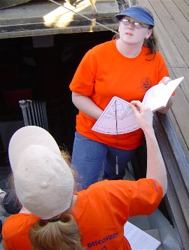
| The quadrant is a navigational
tool, used to measure the height of celestial objects above the horizon,
which first came into wide use in the mid-15th century. Although
sailors in 1609 had no reliable means of measuring longitude (location on the
east-west axis) other than dead reckoning, they could
use quadrants to quickly measure latitude, telling them precisely how
far north of the equator they were.
The quadrant represents a 90 degree arc, or one quarter of a circle, measured from 0 degrees (the equator) to 90 degrees (the north pole -- specifically Polaris, the north star). A navigator who wanted to find his latitude would hold the quadrant to his eye and aim the 90-degree corner at Polaris. (Since Polaris cannot be seen south of the equator, sailors in the southern hemisphere had to develop different astronomical markers to measure latitude there.) Meanwhile, gravity pulls the plumb bob (the dangling weight, right) straight down. When the quadrant is angled correctly, the hanging plumb bob marks its exact degree of latitude.
|
 |
|
Once the underlying principles are understood, a quadrant is not difficult to build or use. The quadrant shown here was created by Mr. Woodworth, who brought it onboard to demonstrate its use to the student crew.
|
|
| Soundings
|
|
|
|
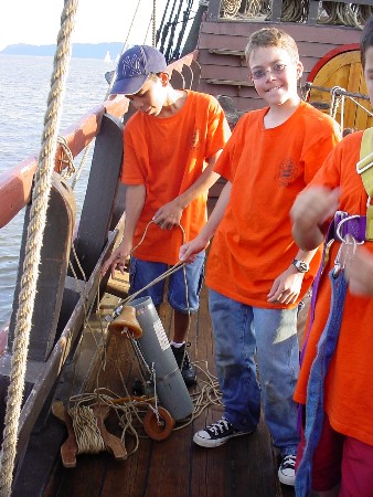
Water depth is an essential
concern on the Hudson River. This is particularly true since the
Hudson's depth can vary by several feet over the course of a tidal
cycle.
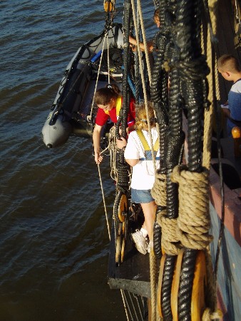
For the obvious reasons, this is particularly vital for mariners, but it's important for local wildlife as well. On the Half Moon, we measure water depth with a sounding line (also known as a lead line), the same kind of instrument Hudson's crew used in 1609. A sounding line is a long length of rope attached to a lead weight at one end. Straps all along its length mark off each 6-foot increment (a fathom). To take a sounding, a crewmember (such as Nicole, left, seen while she charts the tidal cycle) dons a safety harness, steps onto the channel, and flings the lead weight into the water, letting the line run through her fingers. When she feels the weight hit bottom, a quick glance at the marks on the line tells her the river's exact depth at that location.
|
|
Taking accurate soundings does more than just prevent the Half Moon from running aground. Determining water depth is also a crucial first step for many of the scientific experiments below.
|
|
|
|
|
|
For much of its length, the Hudson River is deep
enough that numerous qualities, such as water temperature, can vary
significantly between the surface and the lower depths.
This year, Mr. Swartout provided our voyage of discovery with a Van Dorn sampler, which Abel and Peter are showing off to the right. The Van Dorn sampler is a hollow tube, open at both ends. Its user lowers the sampler into the water to the desired depth, then drops a weight down its guide line, triggering the rubber stoppers visible at each end to snap shut. This traps the water inside, allowing us to take samples from any depth. (Of course, we take a sounding first to determine how deep we can send the sampler; we don't want to sink it into the silt at the river's bottom.) The Van Dorn sampler also enhances our ability to study oxygen levels and salinity, below. |
|
|
|
|
| Oxygen Levels
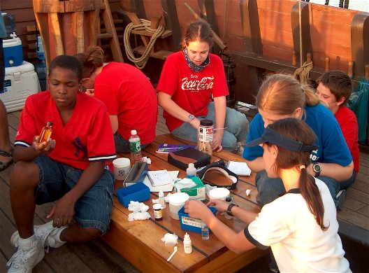
Our student crew also studied dissolved oxygen levels in the river, an important indicator of water quality and a major factor in the river ecology. Both oxygen levels that rise too high and those that fall too low can have deleterious effects on the health of aquatic life. The student crew performed a series of titration tests: multi-step chemical tests that use color changes to indicate dissolved oxygen levels. The students tested different locations on the river's surface (such as the middle of the river vs. nearer to shore) and, using the Van Dorn sampler, sampled different depths as well. Above, we see several students preparing a titration test, including Hannah (right, in blue) who devoted her project to the topic. Hannah found lower oxygen levels in deeper waters (thus farther from the atmosphere) and relatively higher levels along the shore (where aquatic plants release oxygen into the water through photosynthesis), but her findings all fell within acceptable parameters.
|
|
| Salinity
The Hudson River is an estuary: a freshwater river that flows into the ocean, where it mixes with salt water. The degree of mixture between fresh and salt water is called the salinity gradient. On the Hudson, the salinity gradient at a given location can vary considerably depending on factors such as time of year, tidal flow, and precipitation. Salinity can be measured by using a refractometer (as Charles is doing, above). This instrument measures salinity using refraction, the degree to which light bends as it passes through different materials. Saltier water bends light farther than fresher water, so a trained refractometer user can check salinity levels with just a glance. Salinity can also be measured through tritration. In some cases, the students measured salinity using both methods and compared their findings. During this voyage of discovery, we noted that the same recent heavy rains that had flushed so much plantlife into the river had also pushed the salinity gradient far down. In the upper Hudson, the students found absolutely no measurable salinity in the water -- a first for us.
|
|
|
Back to Page One...
|
|